


8
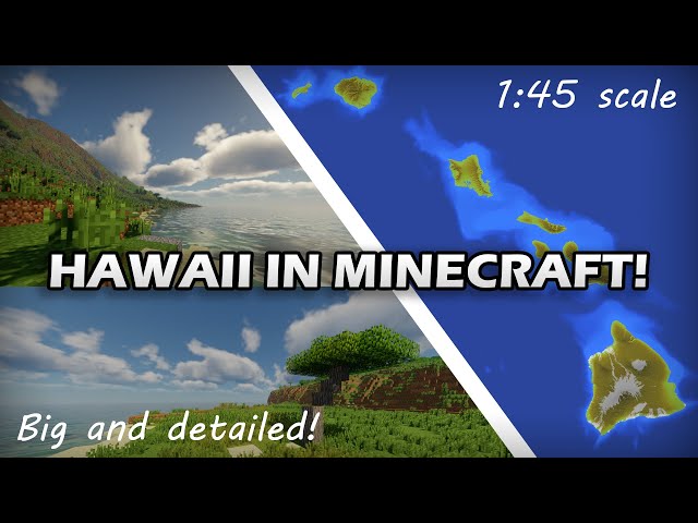
Hello everybody, here it is my latest project, the map of the Hawaii islands. To make this map I used open sourced satellite data in the
programs QGIS and WorldPainter.
You can find the download link in the video description, together with the archive password and more info about the map.
FEATURES of the map:
16.663 x 10.567
1:45 extension scale
1:22 height scale
Realistic land cover
High resolution elevation and bathymetry
SOURCES I used for this map:
Elevation: NASA SRTM 30m tiles
Bathymetry: MHI MBSYN 50m, GEBCO 400m bathymetry
Land Cover: Carbon Assessment of Hawaii 2015, Land Use Land Cover (LULC) 1976
To use the map you need the Java version 1.12.2 or earlier due to world compatibility issues. If you load every chunk with a dynmap then you can use the map with the latest versions. I accept commissions, and this map was one of them.
| Progress | 100% complete |
5356348
2


 AloComet
 Howardeez69
 Night Cheetah
 Rodrigues
 Team UNNAMED
 KrAzY DuDe LR
 RangerRicochet
 ExtremeGames
 prosodic
 HudSolo2009
![🌄Beraxsos, 8k, The Highlands [1.20.2+, Survival Friendly, Download, Java , Minecraft World] Minecraft Map & Project](https://static.planetminecraft.com/files/image/minecraft/project/2024/458/17815147-thumbnail_s.jpg)
 McMeddon
 Toyoni
 TwoManBuilds
 KlimekMC
Create an account or sign in to comment.