


- 3,582 views, 2 today
- 296 downloads, 0 today

237
Release 0.0.2 - the trade village of Iksja has been completed, along with a lighthouse on Char Cape, a watermill near Fisherman's Hut, and the start of Kvorsky Ruins. All biomes have been fixed on all 600 region files, so swamp colour reverters are no longer necessary.
Post-update logs (aka things to expect in next release):
17 December 2012 | I've worked on this map a lot since I had released anything, but had grown less fond of it over time... not sure if I'll complete it, however.
24 May 2012 | Skalka started. Rusvnoka started. Additions to the surroundings of Iksja.
You can see this map on RävmunkenCraft before you download it! This map is best suited to RävmunkenCraft's customised edition of JohnSmith, but the regular version will be adequate.
Because the map is so huge, I had to break the upload into parts for Mediafire. As such, there are three .zip files to download. One is the overall folder, and the other two are the region files. Just unzip these two region compressions into your /region folder, and then you're good to go!
Scroll down for lots of information, backgrounds, and maps!
Download the warps! | DOWNLOAD
Download the ChimneySMP files! DOWNLOAD
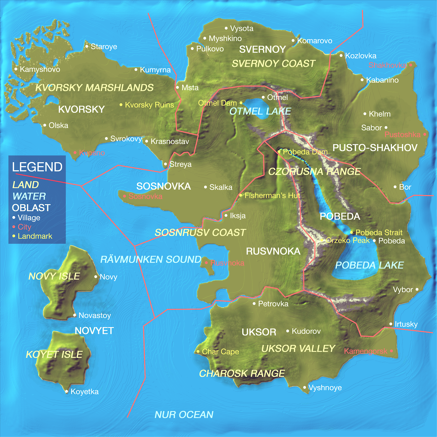
These are the old lands of Rävmunken. Under the former Empire of Rävmunken, all of the oblasts were administrative districts. Since declaring their sovereignty, they no longer recognise any ties to the former Czar of Rävmunken. Nevertheless, the Czar still recognises the oblasts as his territory. It's comparable to the shoguns and the emperor before the Meiji Restoration in Japan. Each oblast has its own story, and all comes together for a wonderful role-play environment.
This map uses an edited version of the texture pack JohnSmith which has removed all the swamp colour files. I will not upload this edited version because I support the great work by the maker of JohnSmith. The files removed are in the /misc folder, if you want to see it as I do. Once the new version of Minecraft comes out, however, I can make it the server texture pack (once the server is up and completed for public use from my own hosting).
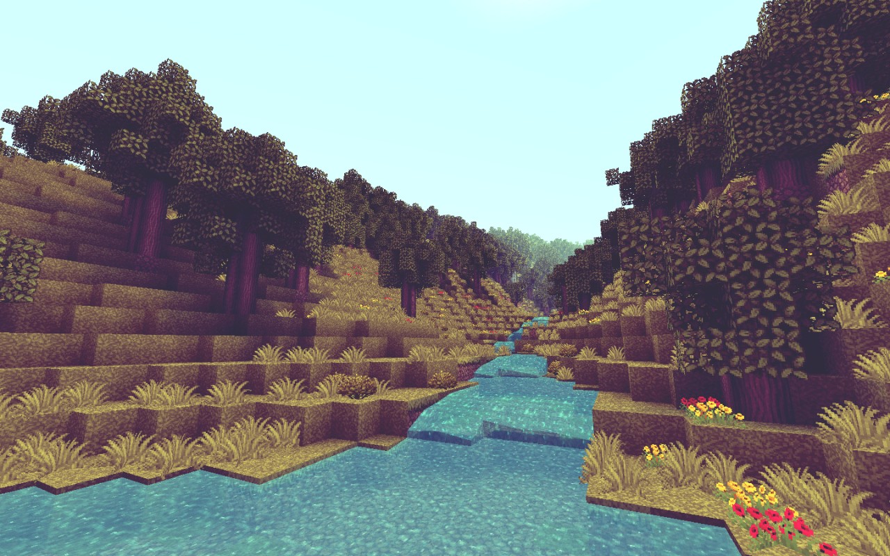
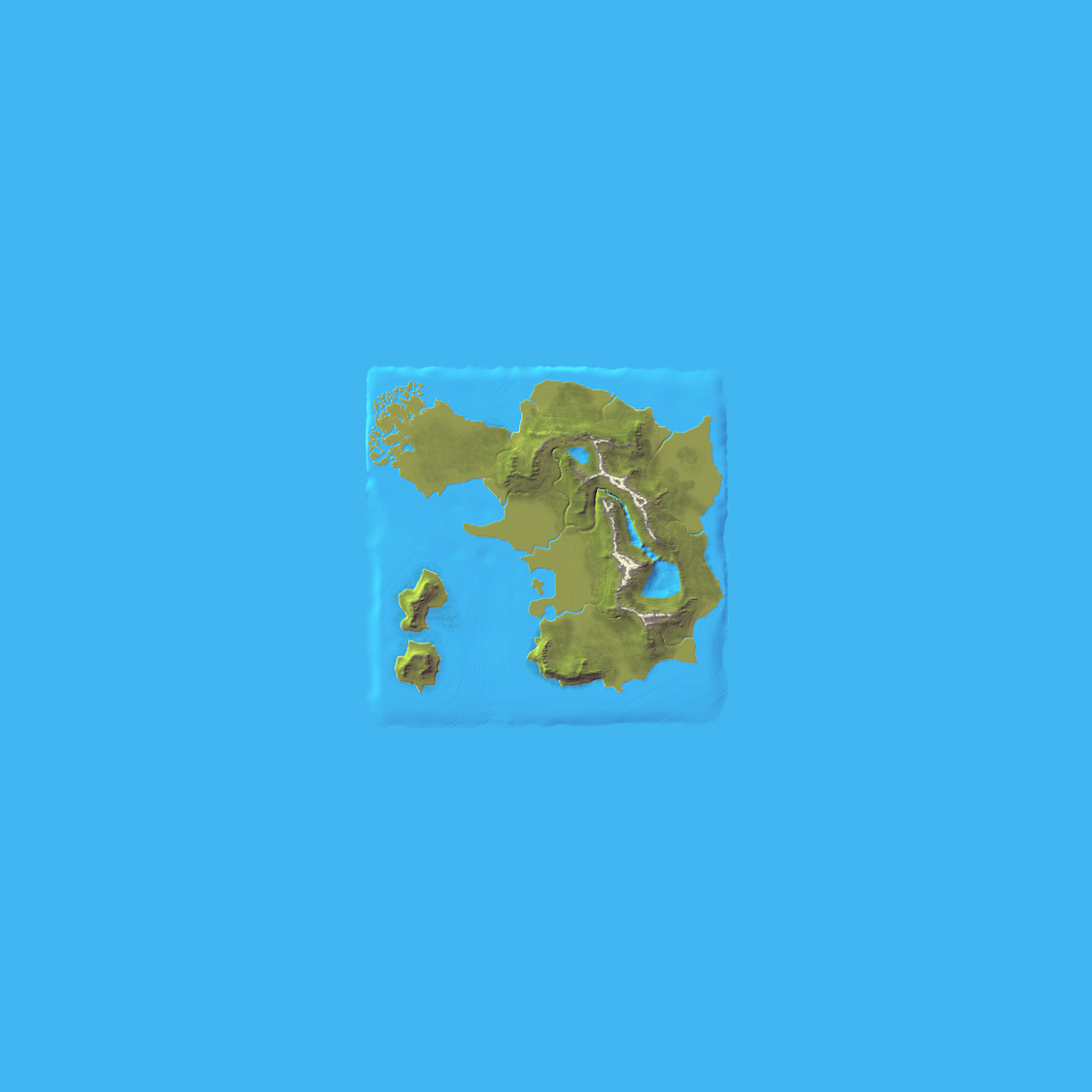
You will first spawn just West of the town of Iksja. The map is 4096x4096 for a playable area, and 12288x12288 for the entire map with its ocean border in the download (4096 ocean border on each side). The map is quite large, so it had to be broken up for uploading (see above for how to piece it together). It was started off as a hand-drawn sketch, then turned into a graphic representation in Photoshop, then turned into a heightmap created in Photoshop, and then worked on in WorldPainter and exported. Seeing tens of hours of time in-game for just laying down bonemeal, nearly the entire terrain has tall grass, roses, flowers, and ferns (or bushes, colloquially). There are gravity-fed rivers added in by hand, with inland lakes far above sea level. The entire underground is populated with resources, with slightly higher levels than default, making the lands of Rävmunken very rich.
So, let's give a little story for each of the regions.
Kvorsky | The lands of Kvorsky are very northern. Despite having rather level terrain, the climate is rather cold, forcing much of the lands to stick to sustenance farming rather than large-scale farming like in the southern regions. As such, many of the towns are smaller and stick to themselves. Kamyshovo is deep in the marshlands, but manages to trade with ships coming from lands afar to the Northwest. The City of Kvosno is the large city of the region, and is southern enough to support farming for trade. It also is a port town, and the roads from it span across the Kvorsky Marshlands. The ruins of Kvorsky Castle and the surrounding town are in the forests of the area, with abandoned mines and vast caverns in the hills to the East. The region was once reigned by the Kingdom of Kvorsky, before the Empire of Rävmunken conquered the lands for itself.
Svernoy | Up North, the Svernoy Coast has rather steep terrain. With a few rivers flowing through its lands, however, it is able to produce sustenance farming for the few small towns on its coast. Despite not having much power and a small capital town of Vysota, the Svernoy region has not been conquered by any of the surrounding areas because of its undesirable terrain. Nevertheless, it is rich in forests and recent mining companies have set up in the southern mountains, fining many metals, coal, and gems. If word of this gets out, those surrounding areas may take interest.
Sosnovka | The first of the two great industrial centres of the lands of Rävmunken, Sosnovka is not only a large port, but also has vast fields for its many farms. The large-scale farming has taken up so much land, the surrounding villages have been swallowed up and incorporated into the City of Sosnovka. The Sosnovka Peninsula serves as a port on all sides, and is very well defended. The other great advantage of the region is its possession of Otmel Lake in the North. Having built the Otmel Dam to control its flow, the river has been partially turned into an aqueduct to serve the large fields of wheat. With a large population and important foreign ties, Sosnovka is an intimidating power.
Rusvnoka | Just South of the other great power, Rusnovka has nearly everything that its northern rival has. Large-scale farms cover the inland plains. The harbour is a safe place for trading ships, making a more desirable stop than up in the Sosnovka Peninsula. It is also very well industrialised and heavily defended in the City of Rusvnoka. The only downfall is its lack of control over Pobeda Lake. Just above its border is the Pobeda Dam, which limits the water that can flow through to the farmlands of the region. While breaking out into war over water would certainly damage the stability of Rusvoka, its need for the refreshing nectar of the mountains pushes its relationship with Pobeda to the limit. Just as Sosnovka is, Rusvnoka is ready to fight and conquer.
Pusto-Shakhov | Unlike most of the other regions of Rävmunken, Pusto-Shakhov is an alliance. To be fair, its more than just an alliance - the former oblasts of Shakhovka and Pustoshka actually joined together, putting aside their desires to have their leader have power over the other in order to defend themselves well. The City of Shakhovka and the City of Pustoshka are well industrialised and great ports with lots of farms surrounding them, yet not near the size of Sosnovka or Rusvnoka, so they decided that together they would be able to take on either of their rivals to the West. The villages in the foothills of the Czorusna Range are well off to do for farming villages, and all together have a strong network of trade and friendly ongoings between the rich and the poor.
Pobeda | Pobeda is home to the great inland Pobeda Lake, a large source of water. The Pobeda Dam has held back so much water that it nearly overflows the low point at the town of Pobeda on the Southeast side of the lake. Despite having a small population and surviving on not much more than sustenance farming, the region of Pobeda has such steep terrain, encompassing much of the Czorusna Range, that it is hard for any invading forces to come uphill. Its warriors are well suited to the terrain, having lived there for centuries. Legends tell its archers have been said to hit their targets up to a kilometer away.
Uksor | With the Czorusna Range and the coastal Charosk Range closing in the Uksor Valley, the towns of Uksor are in a choke point. The roads don't go much more out of the way than necessary, leading from the river by Petrovka to the Nur Ocean by Vyshnoye. Despite this, their fortunate acquirement of the City of Kamengorsk allows them to be industrialised like the other powers. The Uksor Valley offers farming at less than large-scale levels, but their use as trading posts to the South has declined with the rise of nautical technology. Once the independent Kingdom of Uksor, the ancient wooden architecture has been far decomposed with time, and the formerly mighty kingdom only survives in name.
Novyet | The dormant volcanic isles of Novy Isle and Koyet Isle are not well populated, but a wise grouping of power between the towns to form Novyet has pushed their status as small villages to safe harbours along the way for southern and western ships. Their steep mountainous terrain from their volcanic past has made it hard for large forests to grow and even harder for farmland to be developed, despite the mineral rich soil. The diet of a Novisian of a Koyetan mainly consists of fish and wild edibles, but is a very healthy diet nonetheless.
Settlements on the map.
Kvorsky | NW
Kamyshovo | 0%
Staroye | 0%
Kumyrna | 0%
Olska | 0%
Kvosno | 0%
Svrokovy | 0%
Krasnostav | 0%
Streya | 0%
Svernoy | N
Msta | 0%
Pulkovo | 0%
Myshkino | 0%
Vysota | 0%
Komarovo | 0%
Sosnovka | Central N
Sosnovka | 0%
Skalka | 0%
Otmel | 0%
Rusvnoka | Central S
Rusvnoka | 0%
Iksja | 100%
Pusto-Shakhov | NE
Kozlovka | 0%
Kavanino | 0%
Shakhovka | 0%
Khlem | 0%
Sabor | 0%
Pustoshka | 0%
Bor | 0%
Pobeda | SE
Pobeda | 0%
Vybor | 0%
Irtusky | 0%
Uksor | S
Petrovka | 0%
Kudorov | 0%
Vyshnoye | 0%
Kamengorsk | 0%
Novyet | SW
Novy | 0%
Novastoy | 0%
Koyetka | 0%
This is the map of the playable regions. Each dot also counts as a warp. | FULL SIZE
This is the terrain map. It is what the natural terrain looks like, minus post-edited rivers. | FULL SIZE
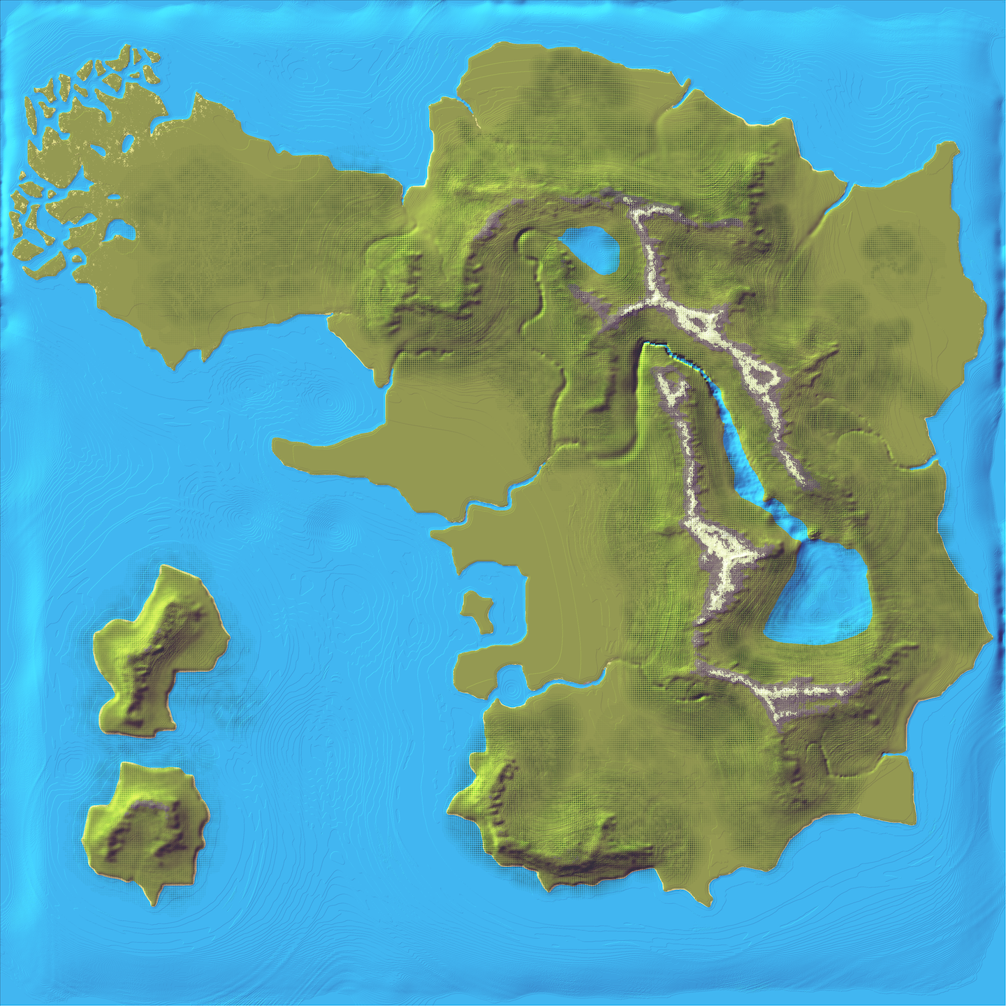
This is what the entire map looks like with the ocean border. | FULL SIZE
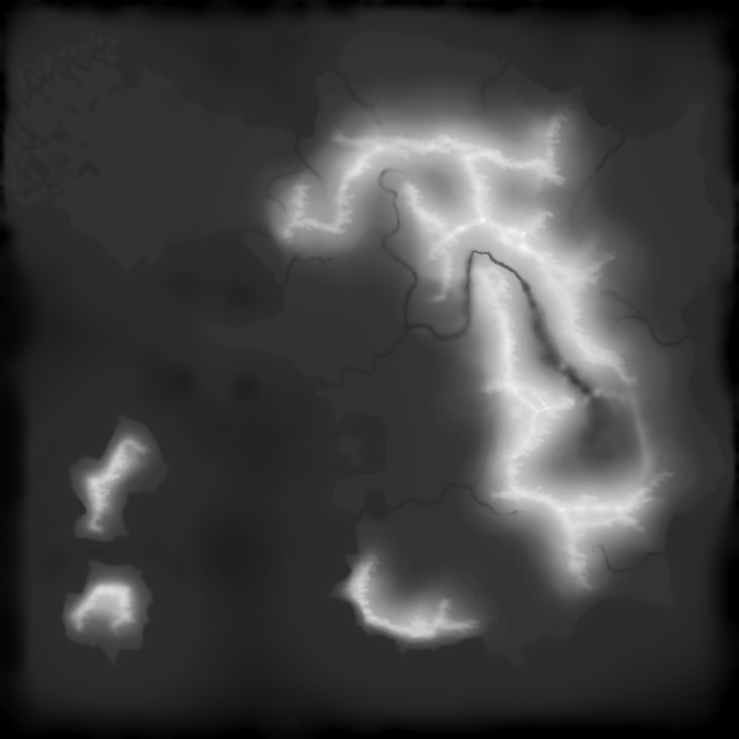
This is the heightmap of the playable area. | FULL SIZE
Here is what I will consider my progress.
15% | Exported from WorldPainter.
20% | Terrain issues resolved.
25% | Terrain fully edited via WorldEdit.
30%-95% | Settlements in progress.
100% | Obscure structures completed.
Notable features.
¦ Very large landscape.
¦ Rolling hills, wide pastures, marshes, islands, and steep fjords.
¦ Inland lakes and gravity-fed rivers.
¦ Many cities and towns.
¦ Russia/Caucasus themed map.
¦ A variety of settlement structure types.
Here is the archive of the development screenshots.
¦ 11 May 2012
¦ 22 May 2012
Here is the archive of the world saves.
¦ 0.0.1
¦ 0.0.2
I have included the WorldPainter ".world" file, which is raw and unedited, but a fraction of the size of the edited world files.
You're free to use this for personal use or for servers, but please don't redistribute it. If you want to make your own buildings on the structure-less version of the map (version 0.0.1) and release it, however, please consider referencing me in your info.
Current uncompressed size | 2351.23 MB
Current compressed size total | 252.27 MB
Sovereign Oblasts Of Rävmunken | 0.04 MB
Region A | 109.41 MB
Region B | 142.82 MB
Post-update logs (aka things to expect in next release):
17 December 2012 | I've worked on this map a lot since I had released anything, but had grown less fond of it over time... not sure if I'll complete it, however.
24 May 2012 | Skalka started. Rusvnoka started. Additions to the surroundings of Iksja.
You can see this map on RävmunkenCraft before you download it! This map is best suited to RävmunkenCraft's customised edition of JohnSmith, but the regular version will be adequate.
Because the map is so huge, I had to break the upload into parts for Mediafire. As such, there are three .zip files to download. One is the overall folder, and the other two are the region files. Just unzip these two region compressions into your /region folder, and then you're good to go!
Scroll down for lots of information, backgrounds, and maps!
Download the warps! | DOWNLOAD
Download the ChimneySMP files! DOWNLOAD
These are the old lands of Rävmunken. Under the former Empire of Rävmunken, all of the oblasts were administrative districts. Since declaring their sovereignty, they no longer recognise any ties to the former Czar of Rävmunken. Nevertheless, the Czar still recognises the oblasts as his territory. It's comparable to the shoguns and the emperor before the Meiji Restoration in Japan. Each oblast has its own story, and all comes together for a wonderful role-play environment.
This map uses an edited version of the texture pack JohnSmith which has removed all the swamp colour files. I will not upload this edited version because I support the great work by the maker of JohnSmith. The files removed are in the /misc folder, if you want to see it as I do. Once the new version of Minecraft comes out, however, I can make it the server texture pack (once the server is up and completed for public use from my own hosting).
You will first spawn just West of the town of Iksja. The map is 4096x4096 for a playable area, and 12288x12288 for the entire map with its ocean border in the download (4096 ocean border on each side). The map is quite large, so it had to be broken up for uploading (see above for how to piece it together). It was started off as a hand-drawn sketch, then turned into a graphic representation in Photoshop, then turned into a heightmap created in Photoshop, and then worked on in WorldPainter and exported. Seeing tens of hours of time in-game for just laying down bonemeal, nearly the entire terrain has tall grass, roses, flowers, and ferns (or bushes, colloquially). There are gravity-fed rivers added in by hand, with inland lakes far above sea level. The entire underground is populated with resources, with slightly higher levels than default, making the lands of Rävmunken very rich.
So, let's give a little story for each of the regions.
Kvorsky | The lands of Kvorsky are very northern. Despite having rather level terrain, the climate is rather cold, forcing much of the lands to stick to sustenance farming rather than large-scale farming like in the southern regions. As such, many of the towns are smaller and stick to themselves. Kamyshovo is deep in the marshlands, but manages to trade with ships coming from lands afar to the Northwest. The City of Kvosno is the large city of the region, and is southern enough to support farming for trade. It also is a port town, and the roads from it span across the Kvorsky Marshlands. The ruins of Kvorsky Castle and the surrounding town are in the forests of the area, with abandoned mines and vast caverns in the hills to the East. The region was once reigned by the Kingdom of Kvorsky, before the Empire of Rävmunken conquered the lands for itself.
Svernoy | Up North, the Svernoy Coast has rather steep terrain. With a few rivers flowing through its lands, however, it is able to produce sustenance farming for the few small towns on its coast. Despite not having much power and a small capital town of Vysota, the Svernoy region has not been conquered by any of the surrounding areas because of its undesirable terrain. Nevertheless, it is rich in forests and recent mining companies have set up in the southern mountains, fining many metals, coal, and gems. If word of this gets out, those surrounding areas may take interest.
Sosnovka | The first of the two great industrial centres of the lands of Rävmunken, Sosnovka is not only a large port, but also has vast fields for its many farms. The large-scale farming has taken up so much land, the surrounding villages have been swallowed up and incorporated into the City of Sosnovka. The Sosnovka Peninsula serves as a port on all sides, and is very well defended. The other great advantage of the region is its possession of Otmel Lake in the North. Having built the Otmel Dam to control its flow, the river has been partially turned into an aqueduct to serve the large fields of wheat. With a large population and important foreign ties, Sosnovka is an intimidating power.
Rusvnoka | Just South of the other great power, Rusnovka has nearly everything that its northern rival has. Large-scale farms cover the inland plains. The harbour is a safe place for trading ships, making a more desirable stop than up in the Sosnovka Peninsula. It is also very well industrialised and heavily defended in the City of Rusvnoka. The only downfall is its lack of control over Pobeda Lake. Just above its border is the Pobeda Dam, which limits the water that can flow through to the farmlands of the region. While breaking out into war over water would certainly damage the stability of Rusvoka, its need for the refreshing nectar of the mountains pushes its relationship with Pobeda to the limit. Just as Sosnovka is, Rusvnoka is ready to fight and conquer.
Pusto-Shakhov | Unlike most of the other regions of Rävmunken, Pusto-Shakhov is an alliance. To be fair, its more than just an alliance - the former oblasts of Shakhovka and Pustoshka actually joined together, putting aside their desires to have their leader have power over the other in order to defend themselves well. The City of Shakhovka and the City of Pustoshka are well industrialised and great ports with lots of farms surrounding them, yet not near the size of Sosnovka or Rusvnoka, so they decided that together they would be able to take on either of their rivals to the West. The villages in the foothills of the Czorusna Range are well off to do for farming villages, and all together have a strong network of trade and friendly ongoings between the rich and the poor.
Pobeda | Pobeda is home to the great inland Pobeda Lake, a large source of water. The Pobeda Dam has held back so much water that it nearly overflows the low point at the town of Pobeda on the Southeast side of the lake. Despite having a small population and surviving on not much more than sustenance farming, the region of Pobeda has such steep terrain, encompassing much of the Czorusna Range, that it is hard for any invading forces to come uphill. Its warriors are well suited to the terrain, having lived there for centuries. Legends tell its archers have been said to hit their targets up to a kilometer away.
Uksor | With the Czorusna Range and the coastal Charosk Range closing in the Uksor Valley, the towns of Uksor are in a choke point. The roads don't go much more out of the way than necessary, leading from the river by Petrovka to the Nur Ocean by Vyshnoye. Despite this, their fortunate acquirement of the City of Kamengorsk allows them to be industrialised like the other powers. The Uksor Valley offers farming at less than large-scale levels, but their use as trading posts to the South has declined with the rise of nautical technology. Once the independent Kingdom of Uksor, the ancient wooden architecture has been far decomposed with time, and the formerly mighty kingdom only survives in name.
Novyet | The dormant volcanic isles of Novy Isle and Koyet Isle are not well populated, but a wise grouping of power between the towns to form Novyet has pushed their status as small villages to safe harbours along the way for southern and western ships. Their steep mountainous terrain from their volcanic past has made it hard for large forests to grow and even harder for farmland to be developed, despite the mineral rich soil. The diet of a Novisian of a Koyetan mainly consists of fish and wild edibles, but is a very healthy diet nonetheless.
Settlements on the map.
Kvorsky | NW
Kamyshovo | 0%
Staroye | 0%
Kumyrna | 0%
Olska | 0%
Kvosno | 0%
Svrokovy | 0%
Krasnostav | 0%
Streya | 0%
Svernoy | N
Msta | 0%
Pulkovo | 0%
Myshkino | 0%
Vysota | 0%
Komarovo | 0%
Sosnovka | Central N
Sosnovka | 0%
Skalka | 0%
Otmel | 0%
Rusvnoka | Central S
Rusvnoka | 0%
Iksja | 100%
Pusto-Shakhov | NE
Kozlovka | 0%
Kavanino | 0%
Shakhovka | 0%
Khlem | 0%
Sabor | 0%
Pustoshka | 0%
Bor | 0%
Pobeda | SE
Pobeda | 0%
Vybor | 0%
Irtusky | 0%
Uksor | S
Petrovka | 0%
Kudorov | 0%
Vyshnoye | 0%
Kamengorsk | 0%
Novyet | SW
Novy | 0%
Novastoy | 0%
Koyetka | 0%
This is the map of the playable regions. Each dot also counts as a warp. | FULL SIZE
This is the terrain map. It is what the natural terrain looks like, minus post-edited rivers. | FULL SIZE
This is what the entire map looks like with the ocean border. | FULL SIZE
This is the heightmap of the playable area. | FULL SIZE
Here is what I will consider my progress.
15% | Exported from WorldPainter.
20% | Terrain issues resolved.
25% | Terrain fully edited via WorldEdit.
30%-95% | Settlements in progress.
100% | Obscure structures completed.
Notable features.
¦ Very large landscape.
¦ Rolling hills, wide pastures, marshes, islands, and steep fjords.
¦ Inland lakes and gravity-fed rivers.
¦ Many cities and towns.
¦ Russia/Caucasus themed map.
¦ A variety of settlement structure types.
Here is the archive of the development screenshots.
¦ 11 May 2012
¦ 22 May 2012
Here is the archive of the world saves.
¦ 0.0.1
¦ 0.0.2
I have included the WorldPainter ".world" file, which is raw and unedited, but a fraction of the size of the edited world files.
You're free to use this for personal use or for servers, but please don't redistribute it. If you want to make your own buildings on the structure-less version of the map (version 0.0.1) and release it, however, please consider referencing me in your info.
Additional Notes
Current uncompressed size | 2351.23 MB
Current compressed size total | 252.27 MB
Sovereign Oblasts Of Rävmunken | 0.04 MB
Region A | 109.41 MB
Region B | 142.82 MB
| Credit | DesuMotoko / Charlavalamp / CoyeT |
| Progress | 30% complete |
| Tags |
2 Update Logs
Sovereign Oblasts Of Rävmunken | 0.0.2 : by DesuMotoko 06/19/2012 3:17:29 amJun 19th, 2012
¦ Iksja completed.
¦ Lighthouse at Char Cape built.
¦ Fisherman's Hut and nearby watermill built.
¦ Biomes of all 600 region files customised to match map.
¦ Lighthouse at Char Cape built.
¦ Fisherman's Hut and nearby watermill built.
¦ Biomes of all 600 region files customised to match map.
LOAD MORE LOGS
tools/tracking
803595
2
custom-landscape-sovereign-oblasts-of-rvmunken
![[Custom Landscape] Sovereign Oblasts Of Rävmunken | 0.0.2 Minecraft Map & Project](https://static.planetminecraft.com/files/resource_media/screenshot/1225/title-release-2_2175391_thumb.jpg)
![[Medieval Structure] Stonemaiden Inn | 1.0.0 Minecraft Map & Project](https://static.planetminecraft.com/files/resource_media/screenshot/1219/title_1872032_thumb.jpg)
![[Custom Landscape] Great Sands Of Rävmunken | 0.0.1 Minecraft Map & Project](https://static.planetminecraft.com/files/resource_media/screenshot/1219/title_1804427_thumb.jpg)
![[Server Build] Northern Outpost / NorthboundCraft | 1.1.0 Minecraft Map & Project](https://static.planetminecraft.com/files/resource_media/screenshot/1207/title_1451383_thumb.jpg)
![[Custom Landscape] Grand Duchy Of Rävmunken | 0.0.1 Minecraft Map & Project](https://static.planetminecraft.com/files/resource_media/screenshot/1218/title2_1377758_thumb.jpg)
 Hebgbs
 adakjn
 ApparentlySkilled
 Nuclearsheep
 ScotsMiser
 nos1130
 AveryRose25

 AquaLessPantsu
![Custom Terrain for Conquest Reforged [2k x 2k] Minecraft Map & Project](https://static.planetminecraft.com/files/image/minecraft/project/2024/519/17779617-gkarwelxmaekqxi_s.jpg)
 RedrangerBuilds
 Luna_Herobrine
 MyZia
MyZia![Mysthaven [Java 1.20.4+] Minecraft Map & Project](https://static.planetminecraft.com/files/image/minecraft/project/2024/331/17780604-mysthaven-newrender_s.jpg)
 Meowbeard
Create an account or sign in to comment.