


Published Feb 5th, 2021, 2/5/21 3:45 pm
- 6,958 views, 2 today
- 567 downloads, 0 today

76
Texel
Texel (Texeler dialect: Tessel) is the westernmost island of the Wadden Islands, and is also the largest and most populated island of the archipelago. It's part of the Netherlands and lies between the North Sea in the west en the Wadden Sea in the east.
About this project
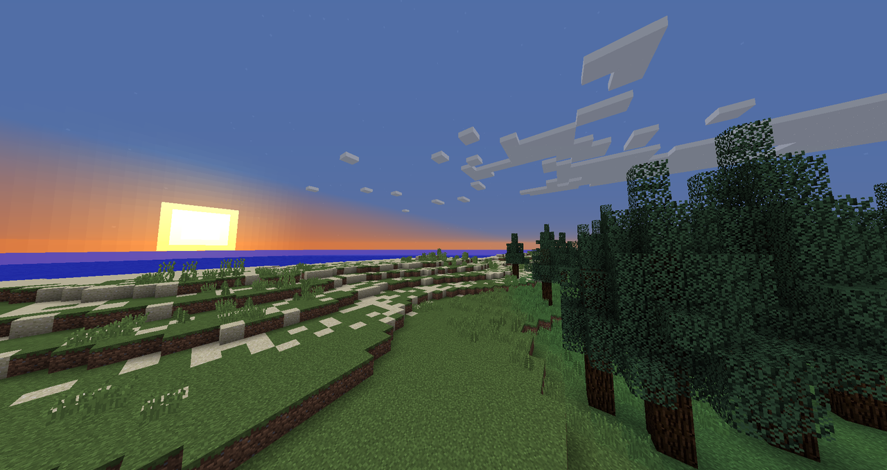
This project is the first build ever of Texel to have been published as a Minecraft map. It was made with the default WorldPainter tools, using heightmaps of the islands and satellite images for reference. The project took me only about three days, but I'm planning to work on it more and add more detail to it. Attempts to recreate Texel have been made before, but as of now this seems to be the only Minecraft map of the island so far.
The Minecraft version for the map is 1.12.
Terrain
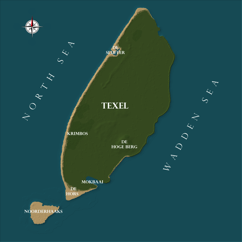
The Texeler landscape is relatively flat, with the highest point of the area being De Hoge Berg. De Hoge Berg (literally: "The High Mountain") is the oldest part of the island and also the highest point of Texel, and is 15 meters above sea level. (Which makes it more something of a hill, really.)
Noorderhaaks (also Razende Bol) is officially a very small island to the southwest of Texel, but consist entirely out of sand and is by most considered to be just a large sandbank. It is part of the municipality of Texel.
Other important landmarks on Texel include the Mokbaai (baai meaning bay in Dutch), the Krimbos (literally: "Crimean Forest"), De Hors and De Slufter. De Hors is a former island, similar to Noorderhaaks, that is now part of Texel's beach, and De Slufter is an area where the sea breaks through the dunes into the land. It's surrounded by the Zanddijk (literally: "Sand Dike") in the east.
The scale of the map is about 1 : 10, meaning that 1 block in Minecraft is about 10 meters in real life.
| General map statistics | |
| Highest point | 57 blocks |
| Sea level | 25 blocks |
| Texel length | 2242 blocks |
| Texel width | 1333 blocks |
| Noorderhaaks length | 263 blocks |
| Noorderhaaks width | 344 blocks |
| Other descriptives | |
| Biomes | Plains, forests, rivers. beaches, oceans |
| Places | De Hoge Berg, De Hors, De Slufter, Krimbos, Mokbaai, Noorderhaaks |
| Scale | 1 : 10 |
About the Wadden Islands

"The Frisian Islands, also known as the Wadden Islands, form an archipelago at the eastern edge of the North Sea in northwestern Europe, stretching from the northwest of the Netherlands through Germany to the west of Denmark. The islands shield the mudflat region of the Wadden Sea from the North Sea.
The Frisian Islands are part of Frisia, homeland of the Frisian people. Generally, the term Frisian Islands is used for the islands where Frisian is spoken and the population is ethnically Frisian. In contrast, the term Wadden Islands applies to the entire archipelago, including the Dutch-speaking islands of Texel and Vlieland."
The Frisian Islands are part of Frisia, homeland of the Frisian people. Generally, the term Frisian Islands is used for the islands where Frisian is spoken and the population is ethnically Frisian. In contrast, the term Wadden Islands applies to the entire archipelago, including the Dutch-speaking islands of Texel and Vlieland."
Wikipedia, the free encyclopedia
![Texel [Scale 1 : 10] [1.12+] Minecraft Map](https://i.imgur.com/HD9psPd.gif)

| Progress | 100% complete |
| Tags |
tools/tracking
3326464
2
texel-scale-1-10
![Texel [Scale 1 : 10] [1.12+] Minecraft Map & Project](https://static.planetminecraft.com/files/resource_media/screenshot/13948605-texel_thumb.jpg)
![Escape Elm Street [1.16.3+] [Custom resources] Minecraft Map & Project](https://static.planetminecraft.com/files/resource_media/screenshot/1911/1-1552842142_thumb.jpg)
![Multiplayer Race [1.12] Minecraft Map & Project](https://static.planetminecraft.com/files/resource_media/screenshot/1724/2017-06-16-19-53-41-1497637727_thumb.jpg)
![CTM: Parkour Style [1.12] Minecraft Map & Project](https://static.planetminecraft.com/files/resource_media/screenshot/1724/ctm-1497472155_thumb.jpg)
 shackfu
 Azure_Flames
 ScotsMiser
 Khangbo84
 TheMountaineer
 MindOfSocial
 Zelvind
 AloComet
 Team UNNAMED
![Riverwind - Hilly Terrain [2,048 x 2,048] Minecraft Map & Project](https://static.planetminecraft.com/files/image/minecraft/project/2024/022/17736413-default_s.jpg)
 Reer123
 emilianaaa
 Threen29
 Xelestial
![Bakkedrag - Mountainous Terrain [2,048 x 2,048] Minecraft Map & Project](https://static.planetminecraft.com/files/image/minecraft/project/2024/898/17732965-default_s.jpg)
Create an account or sign in to comment.