


- 4,210 views, 5 today
- 389 downloads, 0 today

13
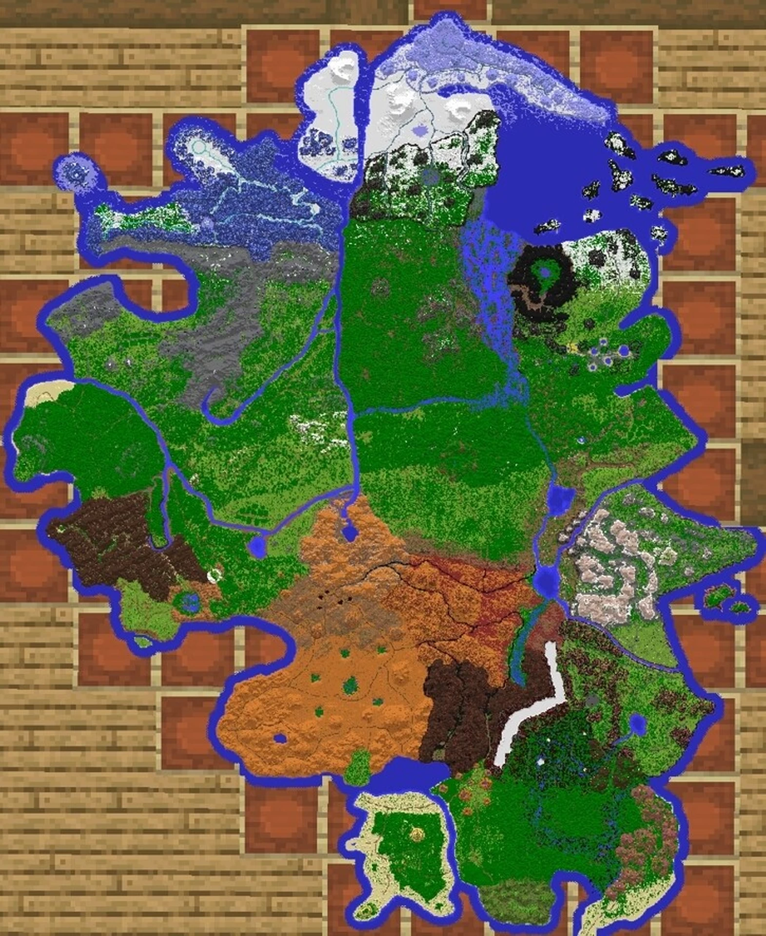
This is by far my biggest and best project yet, a 12k by 10k continent with a road network, lots of biome variety, and a ton of future content based off of this map.
IMPORTANT: Demaria is not a rectangular map, as it's intended to be part of a much larger world I'm making. The larger map will be available hopefully by the end of the year, but it's so big I probably won't be releasing it for free. Most blocks up to 1.17 should be available in at least one region of the map, but Demaria is NOT intended for 1.18.
NEW Discord server: discord.gg/EH2QWSwVYd
Do not claim ownership for this map, and don't use it on public servers. If you make any content with this world in it, please add the link to this page in the description and be sure to mention me.
Anyway, here's a bit of lore for the map. Enjoy the terrain!
ARGENTOUR: One of the most unusual regions of the world, Argentour is a frigid highland with vivid blue terrain and beautiful mountain vistas. Almost no plants grow in the mountains.
Blue Pine Forest: 4200 -5800
Voltaire Isle: 3100 -6300
Argentour Highlands: 4600 -6700
Blue Mountain Valleys: 5800 -5800
Blue Tundra: 6000 -6800
CRUSHBONE: Near the southwestern coast of Demaria, Crushbone is an arid desert region ringed by plateaus, mesas, and mountains. The center of the region is actually below sea level, and cracks into some massive, swampy caverns.
Oil Fields: 6100 -1200
Badlands Edge: 6600 -800
Badlands: 7000 0
Sinkhole Swamp: 6400 -100
Badlands Canyon: 5000 300
Badlands Mesa: 5700 500
Palm Coast: 6500 800
GILEAD: A small region on the eastern coast, Gilead has a vast forest and wide fields in the north and a high, dusty plateau in the south. The region also includes an arid plain surrounding a lake.
Scrublands Lake: 8900 -2200
Scrublands Canyon: 9300 -2800
Dry Highlands: 10000 -2900
Orchard Highlands: 10100 -3500
Gilead Field: 9400 -3700
Thornwoods: 8900 -3500
ILLURIA: The furthest northern region, Illuria is a polar wasteland that extends from a windy, cold plateau in the south across a field of snowdrifts to a massive glacier in the north. Very few plants grow here as well.
Highlands Canyon: 7700 -6300
Highlands Taiga: 7000 -6400
Illurian Expanse: 7500 -7100
Snowdrift Dune: 7000 -7200
Crowned Glacier Highlands: 7400 -8000
Crowned Glacier Peninsula: 9000 -7300
JINGTU: In the center of the continent is Jingtu, a lush region separated into dense forests in the north and sunny plains in the south. The center of the region is home to a magical tree that towers over nearby mountains.
Willow Swamp: 8400 -3800
Deep Woods: 8300 -3300
World Tree Grove: 7700 -3000
Blossoming Forest: 6900 -3100
Lush Plains: 7200 -2500
Lush Plains Edge: 8400 -1800
MAZEROCK: Mazerock is a region with many strange features. Although most of it is a dry, rugged ridgeland, it also includes a dark swamp choked with mushrooms and a massive ravine that hides a network of salt caves.
Red Desert Edge: 8900 -800
Mazerock Arroyo: 9400 -400
Imperial Veldt: 10100 -300
Emperor's Valley: 9700 600
Imperial Gardens: 9600 200
Imperial Marshes: 9100 500
Salt Canyon Edge: 8600 3000
NYX'TOR: Nyx'Tor is one of the most hostile regions on the continent, consisting of a rugged red wasteland stuck between a dry canyon, dark mountains, and a marshy river. The mountains to the south of the region, however, hold the largest caves in the world.
Oasis River Swamp: 8500 -300
Night Mountains: 7900 0
Red Rock Canyons: 7500 -800
Red Desert: 7800 -1500
Scarred Mountains Pass: 6700 -1600
RIVERHILL: The center of the western coast, Riverhill is the largest region and is home to the spawnpoint of the world. The region is surrounded on most sides by water, whether the ocean to the west or a river to the east, north, or south. It's also split in two by a river; the western side is mostly a dense, wooded plateau while the east goes from plains in the south to hilly pine forests in the north.
Great River Falls: 6300 -2300
Plains: 5600 -2200
Meadow: 5400 -2800
White Stone Valley: 6200 -3300
Pine Forest: 6000 -4000
Autumn Forest: 5100 -3400
Greenbridge Basin: 4200 -2800
Redwood Forest Clearing: 3400 -2500
Deep Western Heights: 3000 -3000
Coastal Forest: 2900 -3600
Heitern Hills: 2400 -2800
SALVARO: Although Salvaro's continental portion is very small, the region is also home to a massive tropical island which sits on the southern edge of a shallow, coral-filled lagoon. The island is mostly sandy beaches and palm forests, but the mainland is tropical plains.
Tall Palm Forest: 6900 1600
Tall Palm Beach: 6800 2400
Coral Bay Beach: 7100 1200
Sun Palm Mesas: 8000 900
Palm Plains: 7900 1800
Tropical Moss Hills: 8300 2500
SORSKOGEN: A hilly, rocky alpine region north of Riverhill. Sorskogen is home to a massive canyon which splits the region in two, a towering lonely mountain near the southern border, and a massive gulf on the western coast.
Mt. Greystone: 4700 -4000
Alpine Foothills: 4200 -4300
Alpine Plains: 3600 -4400
Gravel Hills: 3200 -4900
Gravel Beach: 3500 -5500
Alpine Taiga: 4700 -5100
Alpine Canyon: 5200 -5200
Alpine Meadow: 5600 -4500
STONEHILL: The most mountainous region in the world, Stonehill is known for having massive sea cliffs and even more massive mountains. Despite being just east of Nyx'Tor, the region has a temperate or even cold climate.
Cliff Island: 10900 -1300
Highland Meadows: 10400 -2100
Mountain Peak: 9400 -2000
Mountain Valley: 9700 -1500
Baobab Desert: 9100 -1400
Burned Meadow: 10000 -700
TUSCANA: South of Riverhill is Tuscana, a semiarid region with highlands on both sides of a river valley. The west is mostly dominated by dusty mountains and sunny plains, while the rest of the region is more wooded and hot.
Savannah: 5300 -1300
Savannah Lakeside: 5100 -1800
Basin Swamp: 4400 -1200
Mediterranean Plains: 3900 -1000
Dry Mountains: 3300 -1800
Western Heights Canyon: 4000 -1900
WANDERER'S REACH: One of the most uninhabited regions, Wanderer's Reach is a cold, dark region dominated by trees that stand almost a hundred blocks tall. The eastern part of the region is a vast swamp that empties into the ocean.
Giant Taiga: 6600 -4000
Cold Giant Taiga: 6900 -5500
Giant Taiga Mountains: 7600 -4600
Cold Swamp: 8100 -5000
WRETCHMOOR: The furthest southern region, Wretchmoor is a vast, swampy jungle that divides several ranges of hills. It also has a wide stretch of tropical beach and a very large, marshy river.
Jungle: 8500 1800
Jungle River: 9600 1700
Tropical Mountains: 10100 1400
Palm Forest: 10100 2000
Palm Beach: 9800 2500
ZEMLINGARDE: Zemlingarde has the most variety of any part of Demaria. It includes frigid islands, a volcanic canyon, vast tundra plains, a pine forest with hot springs, and a highly unusual valley in the center of a mountain range.
Lush Taiga: 8600 -4100
Hot Springs: 9500 -4200
Tundra Plains: 9100 -4500
Dead Pine Forest: 8500 -5000
Reactor Valley: 8800 -5200
Cold Tundra Plains: 9400 -5500
Snowy Islands: 9700 -6300
Credit to Paralon for allowing me to use their schematics and brushes, lentebriesje and exsilit for tree schematics, and Lapis-kun for coral schematics
| Progress | 100% complete |
| Tags |
1 Update Logs
Update #1 : by Red_Medic 05/21/2022 10:33:10 amMay 21st, 2022
Update V2.1
- Added link to my Discord server
- Added some nether plants to three areas
- Added some coordinates for certain biomes
- Added link to my Discord server
- Added some nether plants to three areas
- Added some coordinates for certain biomes
tools/tracking
5540559
2
demaria-land-of-war
![Anrodica, the Mortal Realm [24k * 18k] [1.17] Minecraft Map & Project](https://static.planetminecraft.com/files/image/minecraft/project/2023/602/17070962-image_s.jpg)
![Upgraded Hyrule [1.19] Minecraft Map & Project](https://static.planetminecraft.com/files/image/minecraft/project/2023/335/16520632-highrule_s.jpg)
![Grullhold [1.17] Minecraft Map & Project](https://static.planetminecraft.com/files/image/minecraft/project/2022/391/15701700_s.jpg)
![Demaria [1.17] [12k * 10k] Minecraft Map & Project](https://static.planetminecraft.com/files/image/minecraft/project/2022/559/15568572-thebestminecraftmapevercreated_s.jpg)
![Neycardan, Isles of the Drakes [1.17, 5k by 5k] Minecraft Map & Project](https://static.planetminecraft.com/files/image/minecraft/project/2021/362/15114771_s.jpg)

![Paralon Continents #3 & #4 - Cynera & Okosha [22K x 20K]](https://static.planetminecraft.com/files/image/minecraft/project/2020/728/13671369-cynera-map_s.jpg)
![Paralon Continent #1 - Aldara [20K x 22K]](https://static.planetminecraft.com/files/resource_media/screenshot/small/13586086-aldarahiresmap_thumb.jpg)
![Azzazir. Land of the impossibility [almost 100 subs special]](https://static.planetminecraft.com/files/resource_media/screenshot/1436/small/azzazir8088312_thumb.jpg)

![Snowdrop River [1000 x 1000 Custom Terrain]](https://static.planetminecraft.com/files/resource_media/screenshot/1852/small/snowdrop-river-120-tiltshift-1545943769_thumb.jpg)
 thelastcraftbender
 EarthUser
 Team UNNAMED
 User5115289G
 MindOfSocial
 Silabear
 Papa Enny
 Titanbornmc
![Riverwind - Hilly Terrain [2,048 x 2,048] Minecraft Map & Project](https://static.planetminecraft.com/files/image/minecraft/project/2024/022/17736413-default_s.jpg)
 Reer123
 emilianaaa
 Threen29
 Xelestial
![Bakkedrag - Mountainous Terrain [2,048 x 2,048] Minecraft Map & Project](https://static.planetminecraft.com/files/image/minecraft/project/2024/898/17732965-default_s.jpg)
Create an account or sign in to comment.